Monday, January 20, 2014

Mt Kosciuszko adventure


Above: my walk circuit clockwise is indicated in fat red dots. 
(click on photos for large versions) 

Below: my panorama from Mt Kosziusko 2200m 


Below : Thredbo area in Winter... 


For the Christmas break, I drove down south and visited an ex-army friend near Sydney. Then Drove to Thredbo for an alpine hike. 

Wed 1 jan.

Dead Horse gap ->   thredbo chairlift and down then up and camp to east of lake cootapatamba.  Zero deg wind chill.


Thredbo township


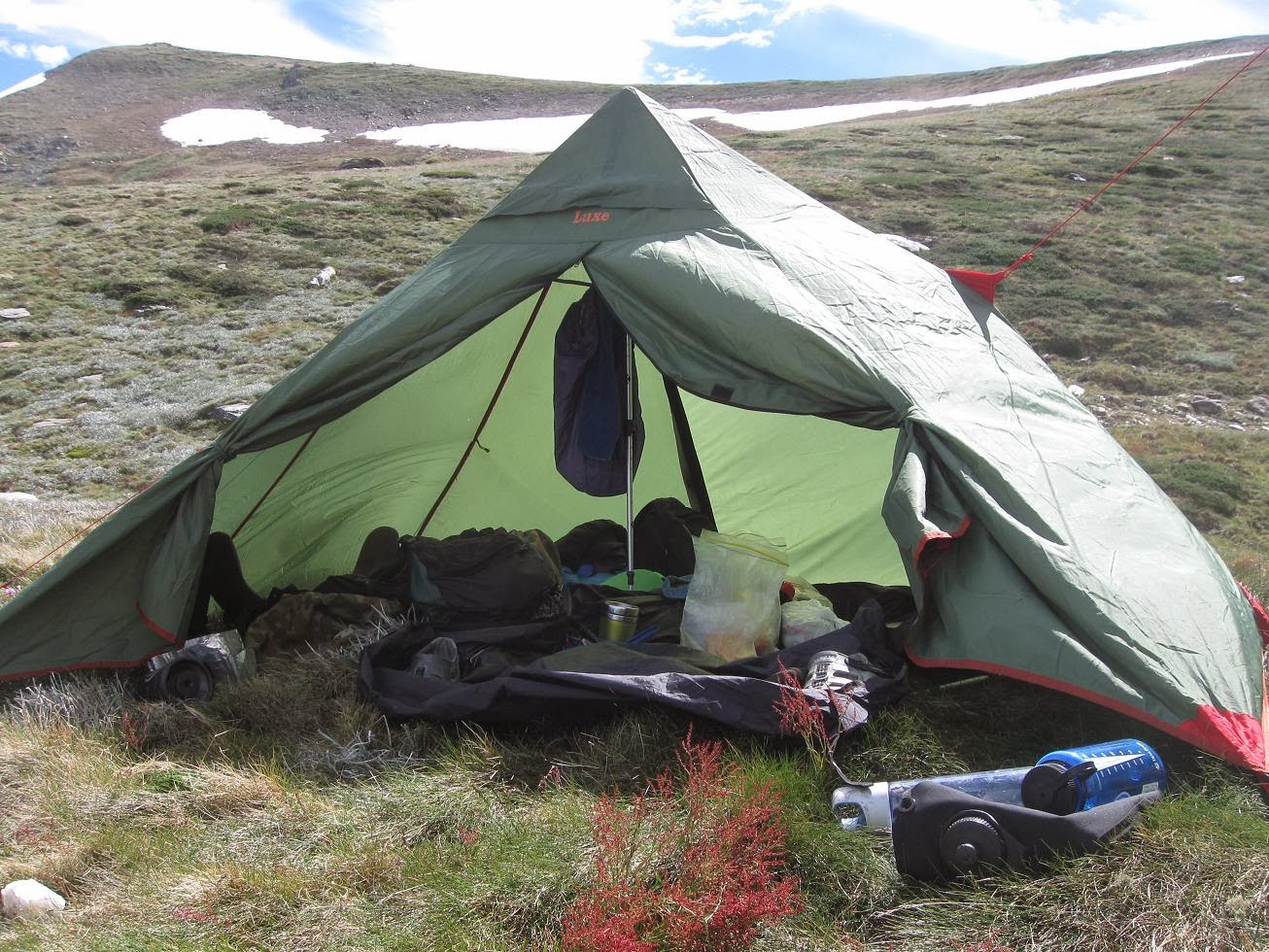
Dead horse gap to thredbo chairlift.   Rain drizzle and 60 km/h wind at top.  Zero deg wind chill. Cold hands… have a schnapps and hot choc then down chairlift to buy a pair of gloves at Thredbo. My windproof hat works v well but I hadn’t quite expected this much cold. Morale: for mountains, pack as if winter…. It can snow in summer.  Hesitate to come back up… maybe I should go tomoro when its predicted better weather… but decide I must test my pyramid tent etc in wind and rain. At top, no rain but cold wind.  Walk a few km on metal ramp then veer right downhill to try to find some shelter from wind..  pitch tent in strong wind,  some rain, with gloves. Glad to be in… put extra guy ropes. 

Evening – rain squalls, tent resists but is buffeted by wind. Later find out 100km/hr peaks… some people had buckled aluminium tent poles… my simple pyramid tent of 1 kilo (1 trekking pole on a rock, 1 fly, no inner, small groundsheet for ants and wet ground) held up.. needs a few more guy ropes to avoid some flapping. Woken at 2am with gale force winds.. bad night sleep, but dry.   Down jacket a must as it was cold as. 


Thurs 3 Jan

Sunny but cold.   On to kosi summit,  then Club lake


Last few photos: Campsite at Club lake, alpine flowers. 


Sunny but cold wind – the best day weather wise.  Up back to track ,  good view over lake cootapatamba which reminds me of French alps.  Up Kosi,  nice panorama with clouds blowing over (see video above) .  French tourist and others .  Lots of snowdrifts – it had snowed down to Thredbo 1000m in Dec 1st week and 20 cm at 2000m… yikes !
Then along ridge track “Main range track”  past pretty lake Albion,  feeling tired from last nite also a bit dizzy from altitude , camp early at 1400, down near Club lake.  I find rock to shelter from wind.  The sun is glaring and burning – I take shelter in tent. Alpine region… no joke – its tends to alternate between freezing or boiling…

I eat and drink and feel better when sun gets lower on horizon. 
Good nights sleep, little wind. Good freeze dried meal. 
Read on my kindle – “Alexis de Tocqueville: On Democracy In America”  he nails the strengths of the USA versus Europe, stuck in class systems , royalty, grumpy working class.  Notes the strength of associations in USA – road associations, etc, and spiritual life – churches are full.

The US has lost its way and is becoming a bad copy of France… bureaucratic, socialist and sclerotic with large swathes of people being pandered to and patronized as helpless by big daddy govmt,  living on hand-outs and not being encouraged to better themselves (on the contrary, a large number of serfs is the bread and butter of demagogues and other snake oil salesmen.)

 Definitely not good news for the rest of us, as the USA has the only really functioning free world army that can project force and thus tame the appetites of dictators from Iran to Libya and assorted maniacs and death cult  terrorists.
Not to mention its economy largely acts as a locomotive for old Europe.


 Fri 4 Jan

Overcast. Rain afternoon with some fog.   Long day -8 hrs walk.  To charlotte’s pass, along 4wd track to kosi. Branch off shortcut via snow pole line to track back to chairlift.  Then branch off back to dead horse gap.


Lake Albion  

The famous Snowy River (man from snowy river) just before Charlottes pass 


The snow pole line and fog . 

Feeling fairly fit.  Long downhill to charlotte’s pass,  then up 4wd track easy, short cut along snow pole line. Weather gets worse –fog and rain. To test my nav as well… I take a compass bearing on snow poles in case I get a whiteout. Which I almostg do a few times. Snow poles are marked as “old” and they look like they were put there in 1950. A few are missing.  I also count paces , knowing I shld hit the track in 3.3km approx. 
Back down to dead horse gap, rain stops, air gets thicker… next time might be better to spend a day up at 2000m and sleep at 1000m to acclimatize better. 
Big leg stretch, tea, orange juice from my eski after a long day.


Conclusions

A very good  scenic adventure.  Best part of walk is actually deadhorse gap to above tree line. Then goes across to Thedbo chairlift .

To my surprise, I suffered a bit from the altitude. Mild headaches, dizziness. True, I was at 2000m for 3 days. Had I done a day of acclimatization, I might have felt better.  I took Panadol  in the evening for mild headache.. 

Note to day trippers:  leave the car at the free parking at Thredbo, Take the chairlift up then walk west on the track marked “dead horse gap”.  After 30 minutes or so you will come to the amazing snow gums and descend thru them past alpine flowers and brooks (1.5 hrs) . Wild horses if you are lucky. At bottom near road, follow the track along the river back to Thredbo (3km downhill, 1 hr) .  about 3 hours walking total.
Renewed my adventurous spirit and rejuvenated me… I felt 100% - as if I had had an oil change -  when driving back down to cooma.   Thoughts of living in Jindabyne… and doing a winter season there mmm….  Backcountry skiing on gentle slopes old school style.


Organisation 

Overnight hiking:  Lots of packing (hours…) . But will be easier next time …  lots of small details – lighter, toilet paper, compass, topo map, drybag for wallet and phone,  fresh batteries for headtorch, drybags for clothes etc, long johns under shorts looks weird but is the best system for cold winds and drizzle – hard to overheat, and does not get wet and baggy like trousers. 

Tedious to organize, but well worth it … should do more often.
My first more than 1 night tent trek for quite a while… food was basic but ample
  
Rough menu:

Breakfast:
Porridge and brown sugar,   coffee/tea
Cream cheese and crackers

Lunch baked beans can/  crackers and vegemite
Salami , loaf of bread,  / tuna  / cheddar cheese, cucumber


Dinner freeze dried veges (nice) ,  2 minute mi-goreng noodles
Wraps,  salami,  hot choc.

Plus nuts and bars and vegemite tube.
 (5 days off the above weighs 2k kilos)

----------------------------------------------------------------------------------------------


Spend 2 days easy driving on the Newell highway to get back to Brisbane.  Straight runs, little traffic.  Listening to BBC world service on possible mining in Greenland and other interesting subjects.  3 hours to register a business in Rwanda !  versus 3 months in France… there will come a day when Africa will overtake some European countries, weighed down with byzantine regulations and millions of public servants.

I go Past Mt Kaputar nat park in Northern NSW.  It actually snows there in winter sometimes !


Beware of hiking in alpine regions - especially just before winter. This fellow disappeared near Mt Townsend (shown on map) in May 2013.  her had taken the trackless side trip to this mount and a Snow blizzard started and lasted several days. His body lies somewhere on the steep, rocky and bushy side of Mt Townsend.  Sat phone. or sat locator beacon useful then.... I have the first and may take it on my nxt trip. 

Wednesday, January 15, 2014

The Dumbing-Down of Society: Are we Progressing or Regressing ?


Hiking, I sometimes think of previous generations, where boys and girls camped and hiked. Often unsupervised. Eg the novel "swallows and amazons" where 12 yr olds sail and camp on lake Windermere.  We have definitely lost in quality of life since then in terms of carefree activities and lack of supervision for kids.  
And 13 yr olds used to be more educated than most Phds are now... this is not progress.... This is dumbing-down of society A la "Brave New World".  It suits both big corporate and Big government. Makes it easier to pull the wool over the eyes of the masses and get fat checks for running their lives.  

Extract From the book 
Killing Rommel by Steven pressfield

a Historical novel, based on memoirs of an SAS patrol soldier
North africa, 1942
LRDG Long Range Desert Group

P23
Comment of a German captured by a LRDG patrol:
We Germans could never pull of this trick as you do, wandering about on your own, miles from anywhere. We lack the individual initiative. We prefer to run in a pack.

What appeared as unendurable hardship to soldiers of other nationalities produced a species of exhilaration in our lads, raised on a diet of Kipling and institutional porridge
.

At Winchester when I was 13, (…) in winter, water froze in our drinking pitchers. (..) we read in Greek Xenophon's March of the Ten thousand, and in Latin Livy's History of Rome, not to mention all of Chaucer, Milton and Shakespeare, the main of Coleridge, Hardy, Tennyson, Dickens and Conrad, while participating in all weathers in football, rugby, cricket, rowing, riding and track and field, as well as attending religious services 5 times a week.
Many boys saw their parents at holidays only, some not even then. They raised each other like feral beasts with all the outrages and excesses that such an upbringing implies. For most, it worked.


(...) the system produced the kind of individual who frequently displayed boredom or feckless complacency in times of prosperity, but shone in times of trial.

Monday, June 17, 2013

5 day solo Whitsunday Islands Kayak trip.


My itinerary ..
                                  Airlie Beach. Outrigger Regatta


Food... Nutella is especially important 


Campsite at South Molle

                                 View from Spion kop in South Molle island


Lady Island (East side of Whitsunday island)


                                 Campsite at Dugong Beach


View from Whitsunday peak 430m
The Rocky beach NE whitsunday isl.

                                                           Curlew Beach, Hook island
Resting at mid-molle island


also worth looking at:
http://www.douglas.stebila.ca/blog/archives/2010/07/14/airlie-beach-and-the-whitsunday-islands/

An epic 5 day trip.  Night time crossing in wind and rain to South Molle island. Used my black diamond headtorch , which I was glad to see got no salt water inside due to its IP5 rating. set up camp at 11pm and slept thru the rain. 

2 days on South Molle - did all the walks, met some backpackers at the camp, snorkeled - but murky cause it had been raining. 

South molle is lovely and accessible - as you can see in my "south molle" entry . 60$ will deposit you on the beach with jerrycans of water, to be picked up at a date you can choose - so go there and be a castaway !

day3  I crossed the Whitsunday passage, this time in easy conditions - not to hot and little wind. A few rain squalls. Then camped Dugong beach and explored the inlet , finding a tiny island called "lady island".  Day 4 Whitsunday peak - the weather was starting to calm down and I got some views.
Steep walk up thru jungle. great birds and rock wallabies in the campsite. 

330 pm  paddled north and  found a rocky beach... Spartan but got some sleep. 
day5:  paddled across in flat calm to Hook island, beautiful curlew beach. Then big crossing - 2.5 hrs to South Molle. Rested , then back to Shute Harbour. 

Following days I met some Backpackers from Chile, practiced my Spanish. They were making their way around Australia, selling nice jewelry they handmade. They sourced the semi-precious jewels themselves from India and other places. I later chatted to them at the Whitsunday markets. Quite inspiring to see such "alternative" people being relaxed and earning a living outside the mainstream. Individuals travelling and learning languages, trades as they travel is the way of the future... global nomads with internet connections. 

Then I did the Conway nat park  great walk... 30 km plus 8km of road... walking fast and jogging some of the way 9am to 5pm. Hitchhiked back to Airlie. With an Italian traveller I had met earlier... coincidences. He used to be a diving instructor in Madagascar, Honduras... and had been all around Aus in his 4wd. Check out his website:


http://onsoulwalkaboutinaustralia.blogspot.com.au/

Airlie beach has good vibes... healthy kids, smiling people... nicer and less bogan than Townsville. 

And the kayak trip got rid of a few cobwebs.. even got rid of a slightly aching hip. Just goes to show: "no guts no glory".... or "who dares wins" as the SAS likes to say. Strangely  sometimes hard physical activity can cure a sore back or whatever. I had moments of transcendence... looking at sunsets on isolated beaches,     
being greeted by strange loud birds on Dugong beach. No whales this time, tho they have been here since July 6.  I also found I could eat relatively little and not feel hungry. Civilization makes us soft and lazy... if we spend to much time in it. 

But I am not naive... the forest on Whitsunday island has it's dangers - Kudos to the early settlers who cleared some of the wilderness (a sawmill on Dugong bay). Wilderness is thorny, rocky, dark, has biting spiders, ants, centipedes, infections and other things that want you Dead.... not to be underestimated. 


Sunday, June 16, 2013

South Molle Island whitsundays, QLD


                       Scamper water taxi. 60$ return


                                 View south


View  from Spion kop rock

A superb island with history - a family grazed sheep then it was sold and a resort was built.
Great, easy walks. Excellent coral when the water is clear. Cheap nat park campsite. All within 15 minutes by water taxi from Shute Harbour. Or 1hr by kayak.
Very relaxing place.

BEST BUSH WALK - The ‘Spion Kop’ walk on South Molle Island is voted #1 by Australian Geographic for Queensland’s best bush walk


History of South Molle Island

Around 10,000 years ago, at the end of the last ice age, glaciers melted and the Coral Sea rose over the coastal plain, leaving only mountain-tops and ridges exposed as the rocky Whitsunday islands we see today.
The Whitsundays are the traditional home of the Ngaro Aboriginal people. Archaeological research shows that the Ngaro inhabited the Whitsundays, including South Molle island, for at least the past 9,000 years. The evidence includes stone axes and cutting tools found in a stone quarry on South Molle island, numerous fish traps (stone structures made for catching fish) throughout the Whitsundays, and cave paintings. Two Ngaro caves have been found on South Molle island, but only a handful of people in the world know the exact location.
Ngaro men were skilled navigators. European seafarers reported seeing Aboriginal people paddling from Double Cone island to South Molle island, a distance of 21km. Their canoes were made of sturdy three-piece bark capable of journeys on the open sea. The Ngaro Sea Trails are still being used as commercial routes.
Ngaro women collected vegetables, seeds and fruits, and prepared them for cooking and eating.
A great variety of tools, utensils and weapons were used for fishing, hunting, gathering plants and cooking. The most effective and simple tools were broken pieces of rock used for cutting, crushing grains and as axe heads. Other tools included animal teeth and twists of bark.
A quarry of these Aboriginal people on South Molle island can be seen when walking the Spion Kop track.